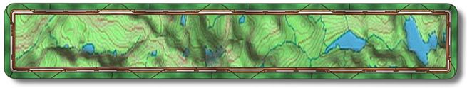
Note: The trail map for this ride exposes something I've never
told anyone. Unfortunately there is no way around it and still provide accurate
information on this ride. As you can see I can ride on water. The Giant XTC
does provide a euphoric riding experience but this ability has been with me
for years. When I was young I discovered I could ride waves, not on a bike
but on a surfboard...
The first time I rode this trail my GPS was running on low batteries so
I thought that was why it showed me in the lake during part of the ride. I
came back a few days later with new batteries and after checking the GPS for
accuracy to see if the track would still indicate that some of the ride was
in the water. It did, but I also noticed that if the lake were at high pool,
which I don't think has happened in a long time, then part of the loop would
be under water.
To get to Hensley Lake from Fresno head north on Hwy 41. Just as you leave
town you will cross over the San Joaquin River and from there it's 9+ miles
to Hwy 145. Make a left on Hwy 145, towards Madera, and then go 8.7 miles
to Road 33 where you'll make a right. In a mile it will "T" at Road
400 where you will make another right. In approximately 9.3 miles you will
come to Buck Ridge Recreation Area, make a left. Just as you enter there is
the pay station ($3) on your right. It's self pay so you will need exact change.
From there the parking (N37 07.2887 W119 52.1647) for trail access is less
than .2 of a mile down the road on your right. There are signs for biking.
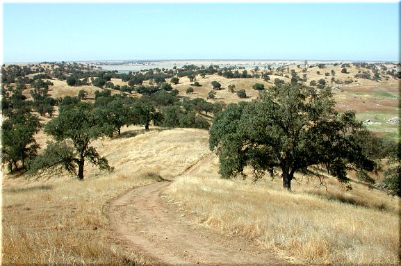
This is a beginner to intermediate ride and is 6+ miles overall.
When you pull into the parking area if you drove straight to the end there
is a metal gate blocking the dirt road, this is the start of the trail. Fifty
yards up the road it forks where there is a bike sign giving you no indication
on which way to go. Make a right onto the smaller dirt road. From here the
trail is a series of loops. I like to get the major climbing out of the way
first so this is the route I took.
In .3+ miles (N37 07.5371 W119 51.9050) there will be another fork, go
right and the climbing will begin shortly, the left fork is the trail you
will return on. Total altitude gain for this ride is only 1050' and 60% of
it is in this first part. You will be topping out as far as max altitude goes
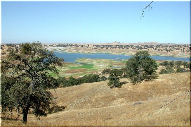
soon. At highest point you will have a view
of the lake and here is a look
back down the trail you just climbed. This not the end of your climbing as
this trail tends to go up and down throughout its length.
Take a right at mile 1 (N37 07.9202 W119 51.7070) where there will be a
single track on your right heading uphill. Then at mile 1.1 (N37 08.0573 W119
51.6613) there will be another fork, it doesn't matter which way you go because
they will come back together shortly. I took the right fork so if you want
your mileage to follow mine go right. In .1 of a mile there are three trails,
the one you are on, the one you could have been on if you went left back at
the left fork and then there is one on your right, which is the one you will
be coming back on from the technical loop. Stay on the trail you are on.
At mile 1.5 (N37 08.2388 W119 51.8960) there will be another three way
junction. If you are a novice you might want to make a left here as the right
takes you to a more technical loop. It's not a hard loop but it is definitely
not a beginner's loop. There are two trails on the right, I took the first
one but either way you end up in the same place. The second trail to the right
wouldn't work when the lake is up.
Mile 2.4+ (N37 08.7480 W119 51.4244), where another loop starts, go right
or left as you will be back here shortly. I went right on this loop, which
is less than a half a mile.
On your way back at mile 3.3 (N37 08.6563 W119 51.4879) there will be a
fork that you will want to go left on. This is a fun, narrow single track
that takes you back to the original loop in about a mile. This trail ends
at mile 4.2 (N37 08.1049 W119 51.7428), which is the intersection of three
trails at mile 1.2 that was described earlier. Make a right at the "T" and
head back down to another intersection that will look familiar.
This intersection, at mile 4.4 (N37 08.2346 W119 51.8912), is the one that
you made a right at to start the technical loop or left if you are a novice.
Go left here to head back to the car. This is where the trail may be under
water so if the lake is full you may have to go back the way you came out.
Unless you are like me and can ride on water.
There will be a fork at mile 5.6 (N37 07.6224 W119 51.9343) where you will
go left. Then at mile 5.7 (N37 07.5442 W119 51.9127) you will make a right
onto the narrow dirt road you came out on, you are less than a half a mile
from the car.