There are three reasons why you might want to do this ride:
You are young and looking for a challenge.
You want to experience the view from the top.
You don't know what you are getting yourself into.
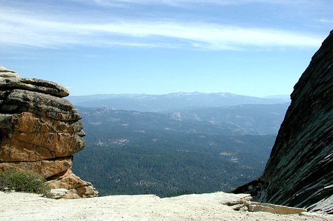
Here is the view from the top of Shuteye Peak.
If you want to see this live and you don't meet the above criteria then
you are a true adventurer. I've done the ride twice now so I guess I would
have to fall into the adventurer category. I've done a couple of rides that
are more demanding but not much more. From Whiskers it's just under 20 miles
and you will have climbed a total of 4300+ feet.
To get there you go north on Hwy 41 to Oakhurst. After passing through
Oakhurst look for the Bass Lake turnoff (Road 222), you can only make a right.
Its 10.1 miles to Central Camp road from here. After going up and over a small
pass the road forks. Go left on Road 274 and take it to the end of Bass Lake.
You will pass by the Marina View development and then right after it you will
see Central Camp Road on the left. You can park on the right and ride from
here but it requires another 13 - 18+ miles of riding. You will get the benefit
of doing the 007 trail at the end of the ride. Otherwise drive up Central
Camp Road for 9.2 miles and park (N37 19.9026 W119 29.5981) on the left just
before crossing the bridge over the creek.
Stretch, pack water and something to munch on for this one. Bring a camera
if you don't mind the weight and/or it's your first time. Head up the road
for 4.2 miles (N37 21.7932 W119 28.8427) or until you see the sign indicating
that Shuteye/Little Shuteye Pass is to your right. After making this right
the climbing will pick up from here on out. At a sharp left turn there will
be a road going to the right, just ignore it and make the left up the road.
In 4 miles you'll come to Little Shuteye Pass, elevation 6960'. You are now
8.3 miles into it and the climbing is just beginning. Saving point here are
the views that you will enjoy the rest of the way to the top of Shuteye Peak.
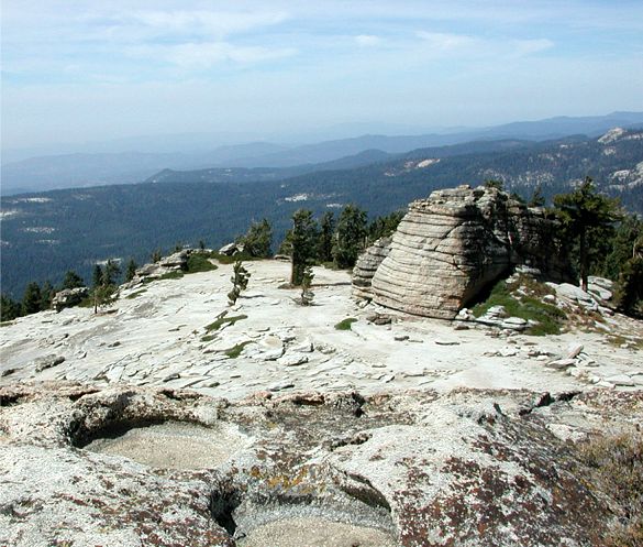
Just above the pass there are several scenic vistas. This shot is looking
north through some great rock formations. And here's another looking
north east from a different angle showing more of the rock formations.
At this point you are only 2.5 miles from the top with just 1500' of climbing
left. Try not to think about these figures when you are there. Keep your mind
on the spectacular scenery. Just .4 of a mile before the top you will pass
the single track you may take back. It will be on your right. I say "may" because
it is no pleasure ride by any stretch. Continue on up to the lookout tower.
The elevation at the top is 8351'. If you have a true 4 wheel drive or
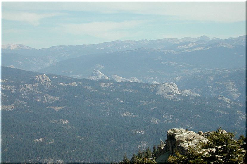
dirt bike you can drive/ride there. The view is the only reason why I ride
up here. The rocks to the north east from right to left are; Fuller Butte,
Balloon Dome, Squaw Dome and Jackass Rock. Balloon Dome and Squaw Dome are
in the distance and appear to be right next to one another. Squaw Dome is
the jagged one on the left. Fuller Butte and Jackass Rock are closer but outside
of those. Fuller Butte is almost directly over the rocky peak in the foreground.
It towers over the San Joaquin River. Jackass Rock is the same distance out
but on the far left.
To the west you can see the valley if it's clear but even closer is Bass
Lake and Oakhurst. This is looking down at the trail
that you ride up to the
top on. Most of the trail for the last few miles is on rock.
Before you turn to stone you had better mount up and head back down the trail.
At mile 11.1 (N37 21.0429 W119 25.8284) you will make a left onto the single
track. This is a very steep technical single track for the next 2.2 miles. It's
not what I call fun at all but it certainly is challenging. If this doesn't sound
good to you go back the way you came.
At mile 12.1 (N37 20.7362 W119 26.5475) the trail can be a little hard to follow.
It's on your left heading down the draw (N37 20.7175 W119 26.5636). Once you
get by this it's easy to follow and in a little over a mile you'll come to a
dirt road. This road is at mile 13.3 (N37 19.9962 W119 26.5304).
For the most part it is downhill on roads like this the rest of the way back.
This road will dump you onto another dirt road at mile 16.8 (N37 20.9798 W119
28.1707) where you will make a left or U-turn to the left. About a mile down
another road will join the one you are on from the left, just stay right (N37
20.3776 W119 28.7397). The road is now partially paved the rest of the way. There
will be a road on your right at mile 18.6 but you will stay on the road heading
left.
In .2 of a mile you come to Central Camp road, mile 18.8 (N37 20.3139 W119 29.2904),
where there will be a sign indicating that Bass Lake and North Fork is to your
left. This is the way back to the car. If you parked at Whiskers your ride will
end at 19.4 miles (N37 19.9026 W119 29.5981). At this point a cold beer might
taste pretty good. That is after 32 ounces of Gatorade.